|
> Impressum
> Profil
> Produkte
> Referenzen
> Publikationen
> Kontakt
Haftungsausschluss
DSGVO Datenschutz
Mitglied im

|
Gunnar Tietze, Wilhelm Weinrebe, Heinrich Hinze
 Handling Bathymetric Data:
Aspects of Bathymetry Data Management
Summary
Marine Science and Technology (MAST) Workshop on Project Data Management, 11-13 June 1997, Ispra, Italy
To handle and process data of offshore and seafloor bathymetry the
swath sonar techniques for measurements, data processing, and archiving
efficient data management techniques are required.
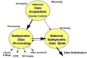
1. Bathymetric and Hydrographic Surveying
The bathymetric survey is the first of three steps in bathymetry data management.
The survey consists in the measuring procedure or data acquisition, the quality control, and the evaluation of the
metadata for the survey. Then, the swath data have to be verified. A first quality control is done by detecting and
removing outliers and blunders. At deep sea, the distance between emitting transducer and reflecting seafloor is
large and results in smaller amplitudes of the received signal at the multibeam system. Noise and errors have a
non-neglectable influence upon the data. Erroneous data may be due to incorrect depth measurements or positioning.
These aspects demand a careful data acquisition including the control of the measurement during survey and they
illustrate the need for an intensive post-mission data processing and verification. Post-mission data control is
done e.g. by manual or semi-automatic swath profile verification.
2. Data Processing
The bathymetric data processing is second step in bathymetry data management.
Following the survey, the data processing is the re-evaluation and merging of data and the processing and production
of results from the bathymetric survey. Since erroneous data still may exist, data have to be verified and
cross-checked for their quality.
Data should be checked at crossings of tracks and for the area of overlapping swathes. When combining separate data
sets, any large difference between adjacent depth values has to be checked. If larger differences between various data
within a small area exist, they have to be analysed. Some smaller data error effects may be detected by visual verification
of the displayed results, since they have a systematic effect which is obvious in mapping. The processing of verified data
by isoline contouring or color-coded depth range mapping may give further hints. However, producing a beautiful picture of
the bathymetric survey data does not significate the last step in data management.
3. Archiving
Archiving, maintaining, and distributing the data are the third step
of bathymetry data management.
Data have to be labelled, metadata have to describe the measurement and processing procedures, and they have to
be archieved.
For swath data, needs for standardized data format have been expressed early and several proposals had been discussed
on a scientific level as well as within the IHO and International Oceanographic Commission committees. The problem is
even more complex, since different types of swath sonar records exist.
The access to the remote expensive resource of a digital data bank has to be installed, allowing a collaboratory as
a new kind of capability in new electronic communication technologies. The successful use of data bank information
requires access to the metadata and an adequate documentation of the bathymetric data. With the potential of fusing data
from quite disparate data bases, collaborative efforts may be raised to a better level of sharing the data and
information among geographically dispersed institutions on an almost instantaneous basis.
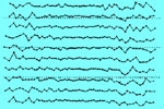
Figure: Swath data noise at about 3850 m depth of an abyssal plane, vertical
beam is at the center of the swath profile data (source: Weinrebe, W. 1997: Hochauflösende Bathymetrie in der
Tiefsee - Probleme und Lösungsansätze. Proc. 12. Hydrographentag, 09-11 June 1997, Würzburg, Germany).
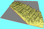
Figure: Swath data noise at about 3850 m depth of an abyssal plane, vertical
beam is at the center of the swath profile data (source: Weinrebe, W. 1997: Hochauflösende Bathymetrie in der
Tiefsee - Probleme und Lösungsansätze. Proc. 12. Hydrographentag, 09-11 June 1997, Würzburg, Germany).
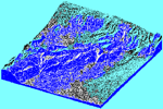
Figure: Shaded relief of a continental slope region boxed multibeam survey at the
Gulf of Alaska (59°N/146°W); area: 80 by 70 km**2 (source: Weinrebe, W. 1997: Hochauflösende Bathymetrie in der
Tiefsee - Probleme und Lösungsansätze. Proc. 12. Hydrographentag, 09-11 June 1997, Würzburg, Germany).
The contibution was presented at the MAST Workshop on Project Data Management,
11-13 June 1997, Ispra, Italy and it is published (p. 53 - 60) in:
Martin Bohle-Carbonell (ed.): Marine Science and Technology (MAST) Program - Experiences in Project Data Management,
Office for Official Publications of the European Communities, EUR 18037 EN / ISBN 92-828-2887-5 / ISSN 1018-5593,
Luxembourg 1998.
|